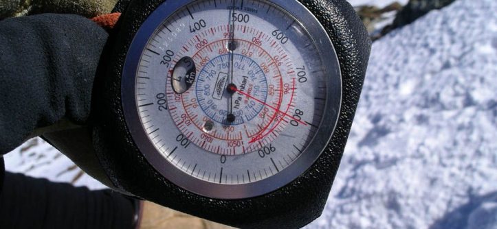
Are you a lover of outdoor activities, running, trekking, mountain biking or hiking? Then surely you have heard of the barometric altimeter. This instrument is incorporated into many route assistants, global positioning system receivers, and sports-oriented heart rate watches, but do you really know what a barometric altimeter is and how it works? We will also see what a barometric altimeter is for, its origin, how it has evolved and its current applications.
WHAT IS A BAROMETRIC ALTIMETER?
It is a measuring instrument used to determine the height above sea level of a point or object. It is based on the measurement of atmospheric pressure due to the variation in the gas volume contained within a capsule of the barometric altimeter. The change in the volume of the gas in the capsule is equivalent to the change in altitude.
They are very useful and important in aeronautics, although currently, their use has spread to a growing public in the area of outdoor sports.
Thus, it is increasingly common to find them in wrist heart rate monitors to offer the height registration of a specific point and determine the accumulated unevenness during a training or sports event.
ITS ORIGIN AND A LITTLE HISTORY
The first barometric altimeters are related to the French physicist Louis Paul Caillet, who experimented with them around 1880.
This instrument was used to measure variations in the height of locations or objects located at high altitude, which could not be measured with other traditional methods.
However, the readings from this first barometric altimeter were not entirely accurate. The German engineer Paul Kollsman introduced some modifications in 1929 that improved the precision. His obsession was to make night flights or those with poor visibility safer, managing to perfect the barometric altimeter.
Until a few decades ago, the altimeter’s most widespread use was to measure the altitude of aircraft, which in aeronautics is called an aneroid barometer.
Today, technologies such as satellite position systems, of which the best known are the American GPS, the Russian GLONASS or the Japanese QZSS, can also measure altitude. However, they have some limitations that affect their reading.
For example, there is a minimum number of satellites that you have to be connected to. And the quality of the received signal is also vital, which can be affected by the rough or deep terrain.
WHAT IS A BAROMETRIC ALTIMETER FOR?
Its use in aviation is mainly associated with outdoor sports and extreme sports such as hiking, mountaineering, skiing, parachuting or trekking.
And it is not only capable of establishing the altitude since a barometric altimeter also serves to predict the weather according to the change in atmospheric pressure.
This instrument allows us to keep an effective record of the altitude changes during a tour so that it saves the information also to offer the data of positive or negative elevation that we have accumulated in our journey.
HOW DOES A BAROMETRIC ALTIMETER WORK?
The barometric altimeter is made up of a capsule that contains a gas inside. This gas has a certain pressure that, when undergoing volume variations due to the pressure change, is translated into measurements of the change in altitude.
That is, its operation is based on the relationship between pressure and altitude. It takes the sea level as an initial reference and from there, the atmospheric pressure decreases as altitude is gained.
It is known that at sea level, the pressure is 1023 millibars and decreases as you gain height. Thus, one millibar of variation in atmospheric pressure is equivalent to 10 meters of altitude.
However, according to latitude, sea-level changes, so the barometric altimeter’s data may be different depending on where the measurement is made.
Thus, as the pressure changes, it is recorded by the barometric altimeter and translated into altitude. It is important to note that pressure is influenced by changes in the weather, so quality barometric altimeters incorporate compensation systems to ensure greater accuracy in the altitude reading.
Advantages of the barometric altimeter
Although its function is analog and must be calibrated (as it does not depend on digital or satellite readings), it offers greater precision if used correctly.
They have been in use since 1930 and are considered the most reliable altimeters in the world.
They can be used for all kinds of trekking or skydiving, although it needs small calibrations.
They are usually accompanied by very useful complementary functions such as thermometer, compass, and GPS.
The most sophisticated models include adaptation to climatic changes so that they do not affect the measurements.
They are resistant to shocks, high and low temperatures or rainy climates.
They are designed to withstand outdoor activities and all conditions common to high altitude sports.
It works even in sparsely inhabited areas as it does not depend on satellite signals.
In addition to the altitude, you can make weather predictions.
They are cheaper than digital devices.
Disadvantages of the barometer and altimeter
Although the portable altimeter and barometer are one of the most reliable, we must be aware of the weather conditions to calibrate the device whenever necessary. Also, we must consider that there is always a margin of error.
In activities such as trekking, where unevenness and different heights are manifested, it is necessary to calibrate each day periodically to achieve more precise measurements.
If the measurement is taken inside a car with the windows closed, it may not be accurate as the pressure inside and outside the vehicle are different. For this situation, digital altimeters are recommended for cars and trucks.
Altimeter measurements may change depending on the country you are in.


Leave a Reply